|
|
|
Relating School Demographics to Census 2000 Demographics School demographics offer an important way to examine demographic composition and trends that can both augment and be used in combination with Census 2000 demographics. School demographics include attributes about students and staff tabulated for individual schools. The main focus here is on student demographics. There are approximately 92,000 public schools for which school demographics are made available annually on a national scope. Although there is a substantial time lag between the reference year and the data availability, there will soon be more recent school demographic data than data from Census 2000. As we move further away from Census 2000, the administrative school demographics will provide a way to examine demographics trends with respect to growth and multicultural shifts. Advantages/Benefits. There are many reasons for wanting to associate school demographics with Census 2000 demographics. Questions that can be partly answered using the school demographics include:
School demographics, as reviewed in this section, relate to enrollment in public schools. In some communities, as much as 25-percent of the persons ages 5-to-19 years of age are enrolled in private schools. There is great variation among communities and school attendance zones as to the public school participation rate. Similarly, some parts of this population are in neither private nor public schools. NCES Common Core of Data. Annual, national scope, public school demographics are available via the National Center for Education Statistics (NCES) of the U.S. Department of Education Common Core of Data (CCD) Program. The CCD program encompasses a national set of school and school district data developed and assembled annually by NCES in coordination with state and local education agencies. For more information on these data, see the Overview of Public Elementary and Secondary Schools and School Districts, prepared by the U.S. National Center for Education Statistics, at http://www.nces.ed.gov/pubs2001/overview/#2. One advantage in using the CCD school data is that the data are organized in the same structure for all schools in the U.S. However, some data fields do not contain data in all fields as some data availability varies from state to state; e.g., Title I eligibility is absent in some state data records (for all schools). A disadvantage in using the CCD school data is that very often data have been revised in local school data systems (operated by the local education agency). Also, most local data systems have data that are as much as two year more recent that the data contained in the CCD files. CCD school level data for all public schools may be accessed via the NCES CCD website at http://www.nces.ed.gov/ccd. The latest school data are for the 1999-2000 school year which corresponds most closely to the Census 2000 timeframe. The NCES CCD webpage that describes the data fields contained in the school data file is http://www.nces.ed.gov/ccd/data/txt/psu99lay.txt. This webpage provides a list of data items available and description or definition of the item. Genesis of CCD2DBF. While anyone can freely access the CCD data in ASCII format, making use of the data requires skilled staff with knowledge of statistical software and the ability to write custom programs. For many applications, such as integrating the CCD data with other data, additional skills may be required. The Proximity CCD2DBF software has been developed to facilitate analysis of CCD school data. The purpose of the CCD2DBF software is to enable a user of the NCES CCD data to convert data for all schools in a county into a form that can be immediately mapped and used with related data in a geospatial analysis context. The CCD2DBF functionality can be summarized with reference to the CCD2DBF operations screen shown below. 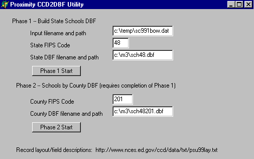
In Phase 1 the CCD schools ASCII file is converted to dbase structure. In Phase 1 the input file referenced is the [expanded] file downloaded from the NCES website. In the above example, the file named contains all schools in states that start with the letters O through W. This application makes use of schools in Harris County (Houston area), Texas. The state FIPS code is set to match the state to be extracted -- 48 (Texas). The state dbf filename is set to reflect the state FIPS code. When Phase 1 completes, Phase 2 is started. In Phase 2, the Phase 1 dbf is reduced in scope to a new dbf which contains schools only in the county of interest (Harris County in this case). The county FIPS code is set to 201 (Harris County). The county dbf filename is set to reflect the state and county FIPS codes. The program is set up in a two-phase manner to enable schools in multiple counties to be extracted. The Harris County FIPS code is specified in the form and the county dbf filename reflect the state and county FIPS code. Since there is no county code in the school record, a process needs to be devised to assign the county code and add it to the data record. In Phase 2, the ZIP code of each school address in the state being processed is checked to see if it is contained in the county indicated by the county FIPS code edit box. If the ZIP code is in that county, the school record is added to a new schools by county file. Most ZIP codes do not cross county boundaries but many do. The algorithm used here associates each ZIP with a county. So it is possible that some schools could be omitted from the output file. After creating the schools by county dbase file, it can be address-matched and used in mapping and geospatial analysis applications. Of the 863 public schools in Harris County, 83 percent (717) were address-matched on the first pass -- resulting in the latitude-longitude of the school's location being added to the school data record. This match rate could be improved by editing the addresses used in the school record. The 717 schools displayed as icons on a map of Harris County appears as shown below. Schools are shown as red triangle symbols. The blue lines are streets/roads. The green lines are census tract boundaries. 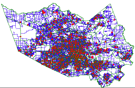
Zooming into an area toward downtown Houston, the streets are more clearly visible as is a highlighted census tract (3101) that is used in other Harris County mapping applications. 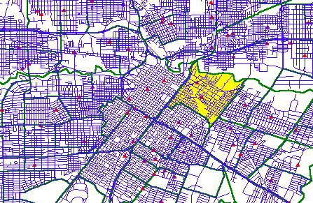
A demographic profile of Rusk Elementary (toward center of highlighted census tract above), is displayed as shown below. The graphic at the right shows the distribution of persons enrolled by grade. Further down in that graphic is the distribution of persons enrolled by race ethnicity category. Though not displayed here, the race/ethnicity breakout is also summarized by individual grade. These shorthand names and their definition is available at http://www.nces.ed.gov/ccd/data/txt/psu99lay.txt. 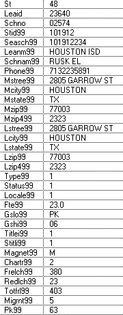
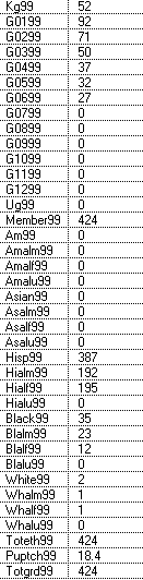
It can be observed from the data in the right graphic above, and the extended (selected) item descriptions below, that there were 387 Hispanic students enrolled at Rusk compared to a total of enrollment of 424. Based on Census 2000 data, the total resident population of all census blocks in tract 3101 (highlighted in yellow above) were 100-percent Hispanic. Selected CCD Administrative School Demographic Items
Census 2000 Demographics by Census Block The map graphics presented below depict Census 2000 demographics by census block for the census tract 3101 -- highlighted in yellow above. Administrative school demographics pertaining to Rusk Elementary pertain to an unspecified set of census blocks, the school attendance zone. Those interested in a next step analysis could examine the boundary for the school attendance zone and compare the Census 2000 census block aggregate data with the school attendance area zone administrative demographics. Population by Census Block - Tract 3101 - with Public Schools 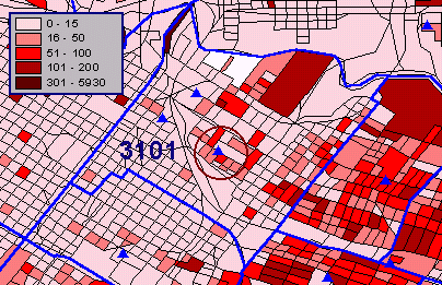
There are thousands of combinations of Census 2000 demographic subject matter items that can be examined by census block. The following map shows one of these -- average family size. Average Family Size by Census Block - Tract 3101 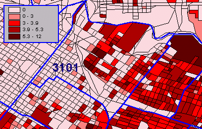
|
|