|
|
|
Congressional Districts Main Page Register for Resources Additional Views & Details |
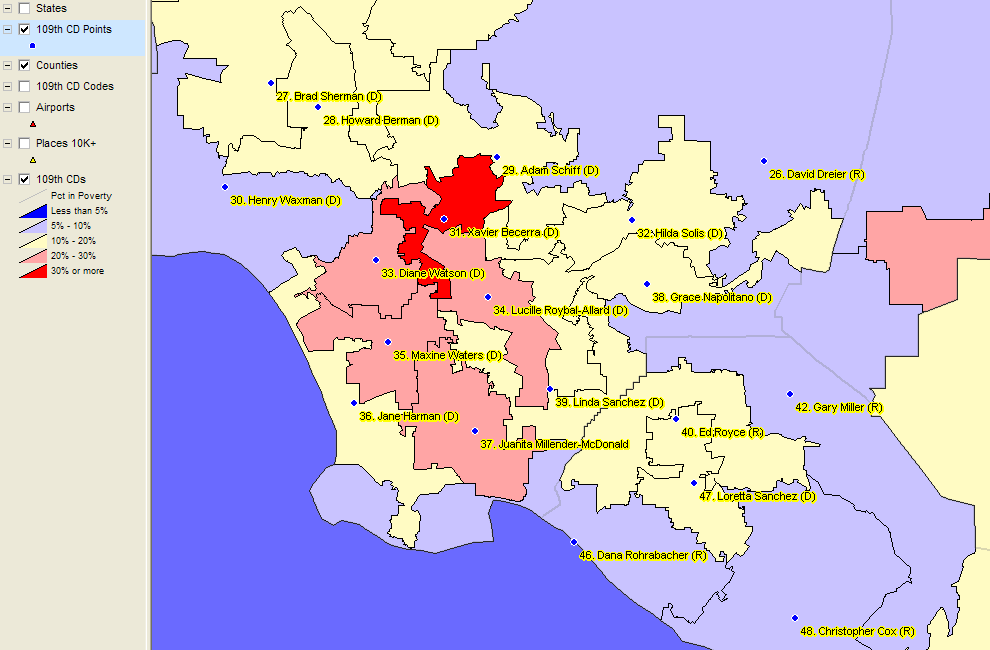
... mapping tool to analyze issues of interest ... ready-to-go data to analyze 109th Congress ... use for advanced applications like coalition analysis ... use in the classroom CDViewer is a specialized version of the CommunityViewer GIS. Easy access to basic operations enable novices and those with more advanced skills to use this resource to analyze congressional districts. CDViewer can be used to address topics to better understand congressional districts: where a particular district is located, the boundaries of specific districts, location and identity of adjacent districts, incumbents in one or a set of districts in a region, characteristics of district(s) of interest. Students can learn more about the district where they live. The visual capabilities make it useful to develop dialogs between students and teachers. It provides a good way to learn about visual analysis and tools with an application focused on topical issues. The start-up screen of the program appears as shown in this graphic: 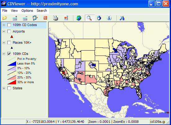
Registered users proceed to use CDViewer in this manner. • Use CDViewer on any conventional Windows-based computer. • Download and expand the zip file to the local computer folder c:\cd109 • The expanded software and data files require approximately 33 MB hard disk space. CDviewer is started like any Windows program from the location c:\cd109\cdviewer.exe. Get started by choosing File|Open and open the file c:\cd109\cd109a.gpr (may appear as only c:\cd109\cd109a with no extension). The map displays (as shown in the above graphic). Summary of features and operations: • Click on/off layers listed in left column (legend panel). • Slide layers up and down in legend panel for different "stacking order" views. • Select a layer, then the identify tool; then click on a congressional district to view its profile. • Zoom-in for close-up views. • Use the pan tool to slide the map view. • Print your map. • Export your map to a graphic. • Create a thematic map based on your selected subject matter with an interval that you define. • Modify the appearance of layers (labels, line thickness, colors, etc.). • Add other map layers. • Add other data to the congressional district database • Use the query tool to locate a congressional district or other area based on your criteria. Registered users are provided access to a tutorial and instructions. Terms of Use • There is no warranty for anything, expressed nor implied. • Neither the software, data, nor related information may be redistributed. • There is no support for the no-fee version other than Web-based materials. • There is no fee for use of CDViewer Version 1 for classroom use. • CDViewer Version 2: - $195 for single user license fee - $495 floating use license fee (appropriate for several users in one organization) - telephone and e-mail support provided - automated ability to add other layers/shapefiles supported - DataView feature enables tabular database viewing, sorting, querying, etc. [goto top] |
|
|