|
|
|
County and Regional Population Trends
-- regional focus on Washington, DC metro area using map project
|
The Washington, DC metropolitan area grew in resident population by 4.25 percent (210,000) between
July 1, 2000 (4,951,411) and July 1, 2002 (5,162,029).
|
The U.S. by County Population Trends Analysis Map Project can be used to
examine county and regional patterns by using the map viewer zoom feature.
The purpose of this section is to illustrate the potential for how you can analyze
county and regional areas of interest to you using the map project.
The files in the
basic map project are supplemented in the following maps with the primary metropolitan statistical
areas shapefile.
DC MSA area maps with numeric percent change and county names are shown at the bottom of this Web page.
Selected data for the DC MSA component areas from the shapefile dbf used in the project are presented in a table at the bottom of
this section.
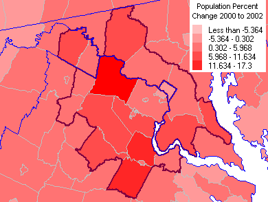
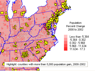
The following graphic shows a zoom into the Washington, DC metro area relative to the
national scope map shown in the U.S. by County Population Trends Analysis Map Project.
Purple outline is the primary metropolitan statistical area. Blue outlines are states and D.C.
The same subject matter and legend are shown in this sequence of maps.
You could, alternatively, select from any of the subject matter items
included in the map project database. See list of items.
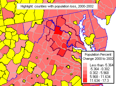
The following graphic shows the Washington, DC metro area with counties in yellow that
had population loss between 2000 and 2002.
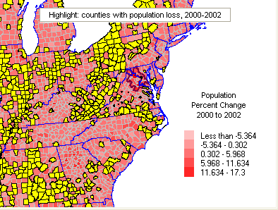
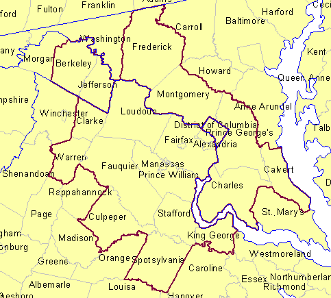
The following graphic shows the broader region surrounding the Washington, DC
metro area with counties in yellow that had population loss between 2000 and 2002.
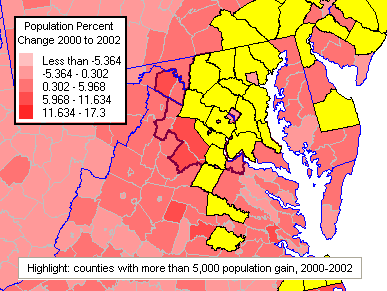
The following graphic shows the Washington, DC metro area with counties in yellow that
had population gain of 5,000 or more between 2000 and 2002.
The following graphic shows the broader region surrounding the Washington, DC
metro area with counties in yellow that had population gain of 5,000 or more between 2000 and 2002.
DC MSA County/County Equivalent Names [goto top]
DC MSA County/County Percent Population Change 2000 to 2002 [goto top]
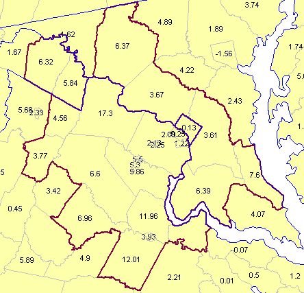
DC MSA Population Trends 2000 - 2002 [goto top]
| County |
State |
Total Population Census 2000 |
Total Population Census 2000a |
Total
Population Estimate 7/1/2000 |
Total
Population Estimate 7/1/2001 |
Total
Population Estimate 7/1/2002 |
Percent Change 2000-2002 |
| District of
Columbia |
DC |
572,059 |
572,059 |
571,641 |
573,822 |
570,898 |
-0.13 |
| Calvert |
MD |
74,563 |
74,563 |
75,191 |
77,721 |
80,906 |
7.60 |
| Charles |
MD |
120,546 |
120,546 |
121,285 |
125,232 |
129,040 |
6.39 |
| Frederick |
MD |
195,277 |
195,274 |
196,599 |
202,441 |
209,125 |
6.37 |
| Montgomery |
MD |
873,341 |
873,341 |
877,944 |
895,021 |
910,156 |
3.67 |
| Prince
George's |
MD |
801,515 |
801,515 |
804,021 |
819,796 |
833,084 |
3.61 |
| Arlington |
VA |
189,453 |
189,453 |
189,445 |
190,092 |
189,927 |
0.25 |
| Clarke |
VA |
12,652 |
12,652 |
12,710 |
13,030 |
13,290 |
4.56 |
| Culpeper |
VA |
34,262 |
34,262 |
34,491 |
35,507 |
36,893 |
6.96 |
| Fairfax |
VA |
969,749 |
969,749 |
975,630 |
988,714 |
997,580 |
2.25 |
| Fauquier |
VA |
55,139 |
55,145 |
55,578 |
57,350 |
59,245 |
6.60 |
| King George |
VA |
16,803 |
16,803 |
16,887 |
17,088 |
17,657 |
4.56 |
| Loudoun |
VA |
169,599 |
169,599 |
173,962 |
190,180 |
204,054 |
17.30 |
| Prince
William |
VA |
280,813 |
280,813 |
283,902 |
298,271 |
311,892 |
9.86 |
| Spotsylvania |
VA |
90,395 |
90,395 |
91,576 |
96,770 |
102,570 |
12.01 |
| Stafford |
VA |
92,446 |
92,446 |
93,626 |
98,703 |
104,823 |
11.96 |
| Warren |
VA |
31,584 |
31,578 |
31,715 |
32,184 |
32,910 |
3.77 |
| Alexandria |
VA |
128,283 |
128,283 |
129,229 |
130,828 |
130,804 |
1.22 |
| Fairfax City |
VA |
21,498 |
21,498 |
21,596 |
21,896 |
22,055 |
2.13 |
| Falls Church |
VA |
10,377 |
10,377 |
10,441 |
10,589 |
10,659 |
2.09 |
| Fredericksburg |
VA |
19,279 |
19,279 |
19,316 |
19,798 |
20,076 |
3.93 |
| Manassas |
VA |
35,135 |
35,135 |
35,410 |
36,070 |
37,288 |
5.30 |
| Manassas
Park |
VA |
10,290 |
10,290 |
10,340 |
10,766 |
10,909 |
5.50 |
| Berkeley |
WV |
75,905 |
75,905 |
76,429 |
78,690 |
81,262 |
6.32 |
| Jefferson |
WV |
42,190 |
42,190 |
42,447 |
43,415 |
44,926 |
5.84 |
goto top
|