|
|
|
Philadelphia-Camden-Vineland, PA-NJ-DE-MD CSA -- Regional & Local GeoDemographics Cities & Places: Composition and Change Which cities are changing the most and how? Which cities seem to offer better business opportunities for a particular type of business? Applications reviewed on this Web page are used in the GeoDemographics WebCourse and are focused on the Philadelphia-Camden-Vineland, PA-NJ-DE-MD Combined Statistical Area (CSA). See main page for overview.  There are 169 incorporated places in the Philadelphia-Camden-Vineland, PA-NJ-DE-MD CSA. These places
range in size from 22 to 1.5 million population. Based on the 2003 population estimates, 2.58 million people live in
incorporated places in the CSA.
There are 169 incorporated places in the Philadelphia-Camden-Vineland, PA-NJ-DE-MD CSA. These places
range in size from 22 to 1.5 million population. Based on the 2003 population estimates, 2.58 million people live in
incorporated places in the CSA.
The graphic the right shows places and airports in the CSA as icons or points. Places of 25,000 population or more appear as blue markers. Places of 10,000 - 25,000 population appear as green markers. Airports appear as red triangles. See this larger map that shows names for cities of 25,000 population and over. WebCourse participants learn how to view places as markers/points or polygon areas and advantages/disadvantages associated with each alternative. In the map at the right, Philadelphia city is represented as both point and polygon. "City/place" geographic entities are important for demographic/economic analyses for several reasons. We often most closely identify with a city/place as compared to larger geographic units or smaller units defined for statistical or administrative purposes. Local site location decisions typically involve an assessment of which city(s) are involved. Incorporated places, to a degree, govern themselves. As a result, they also often have a different lifestyle character than nearby places even in the same county. Most fundamentally, places are areas having a population concentration. Largest 20 Incorporated Places The following graphic shows the largest 20 incorporated places in the CSA based on the latest official population estimate (2003). Annual population estimates are shown are well as change and percent change since Census 2000. 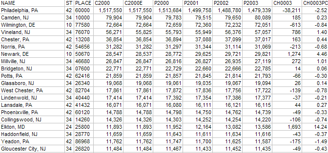
CSA Places (10,000 population or more) & Airports -- names shown for places 25,000 population and over 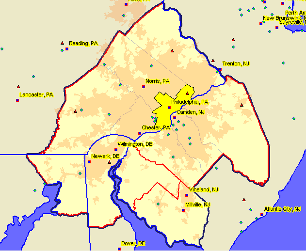
Terms and Definitions: Cities, Places, Towns, Townships and ... The term "place" as used here refers to incorporated places or census designated places (CDPs). Many of us live in "places" that are not incorporated places. These places often have locally known names that refer to areas having no governmental powers and very loosely defined boundaries. The Census Bureau has developed an elaborate program, involving local organizations, for identifying boundaries and tabulating decennial census data for such "census designated places." In New Jersey, some incorporated places have the legal description of "borough." Learn more about these areas, data, and mapping them in the WebCourse. Minor Civil Divisions (MCDs), administrative subdivisions of counties with some legal powers, exist in Pennsylvania and New Jersey (and in 18 other states). MCDs coexist with places and in some cases might have be the same geographic area or have the same name. Post-Census 2000 estimates are developed for MCDs and incorporated places and remainder-of-county MCD and incorporated places. CDPs, as a general rule, are not covered by post-Census 2000 estimates. Better insight into these geographic relationships are shown in two spreadsheets for Camden County, NJ. The Camden County Census 2000 GICS (GICS: Geographic Identification Code Scheme) file shows 87 discrete place/MCD-like geographic areas for which Census 2000 data were tabulated. The Camden County Subcounty Estimates (SUBCTY) file shows 98 discrete geographic areas for which post-Census 2000 estimates are developed. Note that there are no CDPs in the SUBCTY file (for example, "Cherry Hill Mall" exists in GICS but not SUBCTY). While the SUBCTY file has more records/rows that GICS, this is because some geographic areas appear with three different summary levels (see Camden city) in SUBCTY whereas they are represented with two summary levels in GICS. The demographic data values are the same, where applicable. WebCourse participants learn about summary levels and relating these geographic areas and corresponding demographics. Related and More Detailed Data Participants learn how to access related data and drill down to smaller area geography and more detailed subject matter data from sources that include: • Census Bureau American FactFinder • American Community Survey • Current Population Survey [goto top]
|