
|
|
|
A census block group is a set of one or more contiguous census blocks sharing the same first digit of the census block geocode within one census tract. The block group geography is the smallest geographic area for which American Community Survey data are tabulated (5 year estimates). Census 2020 Block Groups
In areas of rapid change, Census 2020 block groups may represent a different geographic area and have different geocodes
than the corresponding area covered by Census 2010 block groups. Census 2020 block group geometry, geocodes, demographics and more
are available for the entire U.S.
See more about Census 2020.
Use the ProximityOne CV XE GIS software and Visual Data Analytics
(VDA) Web GIS to view 2010 and 2020 geography and geodemographics.
Using GIS & GeoDemographics
Whether you are a
GIS
user or not yet using GIS, you can benefit from our self-paced, online course
Using GIS & GeoDemographics.
Learn more about using block group shapefiles and mapping, analyzing wide ranging demographic data at the block group level.
See additional information.
See related sections: • census blocks and block codes • census tracts and tract codes • boundaries defined by TIGER/Line shapefiles • Warren Glimpse blog on this topic ... searchable list of blog posts Use the AddressCoder software to: • determine/assign latitude-longitude coordinates to your address data. • assign tract, block group and block codes to your address data. • assign subject matter (demographics) to your address data. • create a shapefile to map your addresses in context of other geography. Determine Block Group Codes Based on Address • Key in an address to find codes/names based on address. Block groups are geographic areas "sit between" census block and census tract geographic areas. There are approximately 217,740 Census 2010 block groups and average 1,200 population in size. Block groups cover the U.S. from wall-to-wall. Subject Matter Data An important feature of census block groups is that they are the smallest geography for which decennial census and American Community Survey data are tabulated. Their "hierarchical" structure makes it possible to aggregate subject matter data, such as the population of a certain age, to higher level geography including counties, metros, and higher level geography. Vintages Block groups are statistical area geography. Boundaries and codes may be redefined for each decennial census. Census 2010 block group boundaries and codes will generally remain unchanged until Census 2020. There are a few exceptions. Codes, Geocodes & Referencing The codes used to identify block groups (BGs) reflect the basic census geographical hierarchy: the country is made up of states, states are made up of counties (and county equivalents like parishes and independent cities), counties are made up of census tracts, and census tracts are made up of census block groups. Even though a block group code only occurs once in each tract, it may be used again in another tract. Same goes for tracts in counties. A particular census block group within the U.S. must be identified by: its state code, its county code, tract code and its block group code (together the geocode). • States and the territories are identified by a 2-digit code. • Counties within states are identified by a 3-digit code. • Tracts within counties are identified 6-digit code. • Block groups within tracts are identified by a 1-digit code. Combine these codes to uniquely identify a BG in U.S. (12 characters). For example, the BG containing the Office of the California Secretary of State, located at 1500 11th St, Sacramento, CA 95814, is uniquely identified by the code 060670011011. In the map views shown below the table, the address has been geocoded using the APIGeocoder and is shown as a red marker. 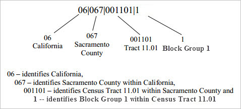
BGs have a valid code range of 0 through 9. BGs beginning with a zero only contain water area and are generally in coastal and Great Lakes water and territorial seas, but also in larger inland water bodies. For the 2010 Census, a block group 0 for the water portion can be delineated in any census tract and not only those census tracts also defined to only include water area. This is a change from Census 2000, when block groups coded 0 only existed in census tracts with a code of 0. Tracts. Block Groups & Blocks by State/Area -- interactive table Click ShowAll button to refresh/reset; click column header to sort on that column; click again to sort other direction. See ranking table usage notes below ranking table. See related ranking tables -- http://proximityone.com/rankingtables.htm. Map View: Census Tracts Tracts are labeled with green tract codes. Address 1500 11th St, Sacramento, CA 95814 is shown by red marker. 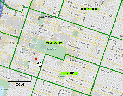 View created using CV XE GIS. Map View: Adding Block Groups Block groups are labeled with red block codes. Tract 06067001101 is comprised of two block groups: 060670011011 and 060670011012. See pointer in map view; the block group within tract boundary. 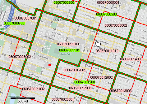 View created using CV XE GIS. Is the tract code 11.01 or 001101? Both. Census tracts within a county are identified by a 4-digit basic code between 0001 and 9999, and may have a 2-digit suffix ranging from .01 to .98; for example, 6059.02. The decimal point separating the 4-digit basic tract code from the 2-digit suffix is shown in Census Bureau printed reports and maps. For geo-referencing, the decimal point is implied and does not appear; the 6-character tract code with lead zeroes is used -- a character string with no blanks and all numbers. Support Using these Resources Learn more about accessing and using demographic-economic data and related analytical tools. Join us in a Data Analytics Lab session. There is no fee for these one-hour Web sessions. Each informal session is focused on a specific topic. The open structure also provides for Q&A and discussion of application issues of interest to participants. ProximityOne User Group Join the ProximityOne User Group to keep up-to-date with new developments relating to geographic-demographic-economic decision-making information resources. Receive updates and access to tools and resources available only to members. Use this form to join the User Group. Additional Information ProximityOne develops geographic-demographic-economic data and analytical tools and helps organizations knit together and use diverse data in a decision-making and analytical framework. We develop custom demographic/economic estimates and projections, develop geographic and geocoded address files, and assist with impact and geospatial analyses. Wide-ranging organizations use our tools (software, data, methodologies) to analyze their own data integrated with other data. Follow ProximityOne on Twitter at www.twitter.com/proximityone. Contact ProximityOne (888-364-7656) with questions about data covered in this section or to discuss custom estimates, projections or analyses for your areas of interest. |
|
|