|
|
|
User Instructions What These Data Can Tell Us Reference Maps Methodology and Subject Matter Description Glossary (PDF) |
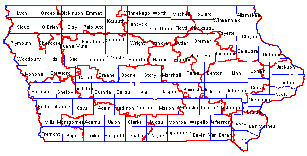
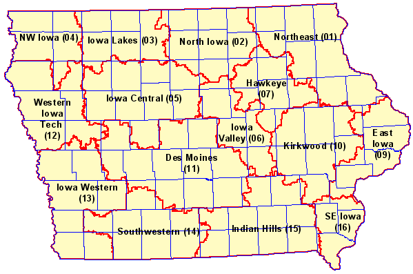
Iowa Community College Area Demographics Comparative analysis demographic profiles for the State of Iowa, Iowa Community College District areas, and Iowa counties may be viewed using this Web page. Based on data from Census 2000, these data provide important information that can facilitate planning and evaluation. Viewing Profiles. To view profiles for areas of interest, proceed with the following three steps: select subject matter, select geographic areas, and click Display. If you are new to this Web page, see the instructions for information on how to use this resource. Source and Uses of the Data [goto top] Data made available via this Web page have been developed by Proximity for subject matter categories corresponding closely to the Census Bureau Census 2000 "demographic profiles." Why use these data? Because they represent the most widely used cross section of demographic data that can be used to assess the overall socioeconomic composition of an area. In addition, using this set of data items makes it easier to compare attributes of school districts with those of counties, communities, census tracts, ZIP code and other types of areas. The standardized demographic profile data structure is augmented with the additional of a table showing educational attainment for the population 18 years and over. These data supplement the data on educational attainment for the population 25 years and over, a part of the standard demographic profile structure, which are also provided. The scope and content of the demographic profiles is described in the technical documentation located at http://www.census.gov/prod/cen2000/doc/ProfileTD.pdf. The technical documentation contains a glossary and related information that may be useful to users of data made available through this Web page -- the comparative analysis profiles. The Census Bureau developed the demographic profiles only for states, counties, places, and other selected governmental jurisdictions. The Census Bureau has not developed these subject matter summaries for smaller geographic areas such as census tracts and school districts. What These Data Can Tell Us [goto top] These data provide important information that can facilitate planning and evaluation. They help enable analysis of the following types of application areas. • Compare community college district1 characteristics using a composite set of key indicators. • Assess 'state of education' -- educational attainment by community college district1. • Analyze attributes of the households that suggest different educational needs. • Assess special education needs using data on children with disabilities. • Assess size of certain populations of interest. • Examine patterns of labor force/employment infrastructure in relation to education. • Assess the need/demand for wide-ranging education-related programs and services. • Examine English language proficiency among school districts. • Analyze number of children in school systems for health and youth development. 1 Community college districts, as well as counties and the state. Reference Maps [goto top] Two Iowa reference maps are presented below. The first map shows the community college district areas and counties with community college district names and codes displayed. The second map shows the same community college district and county boundaries with county names displayed. Use these maps as a reference to make geographic selections easier. 

Methodology and Subject Matter Description [goto top] State and County. State and county level data are derived from the Census 2000 demographic profile files augmented with additional Census 2000 Summary File 3 data on educational attainment. The basic source data for the four types of profiles are described in the following Web links: Table 1 - General Demographics (population by age, race/ethnicity, sex, household/family structure, housing unit occupancy and tenure) Table 2 - Social Characteristics (enrollment, educational attainment, marital status, veteran status, disability, residence mobility, language spoken at home, nativity, ancestry) Table 3 - Economic Characteristics (employment status, commute to work, employment by industry, employment by occupation, class of worker, income, poverty status) Table 4 - Housing Characteristics (units in structure, year built, rooms, vehicles, year moved in, heating fuel, occupants per room, value owner operating costs, gross rent) As a focus of the data provided through the profiles in on educational attainment, the basic educational attainment table (providing data on the population ages 25 years and over in the social characteristics profile) has been augmented to include educational attainment for the population ages 18 years and over. Community College District Areas. The same types of subject matter are provided for community college districts as for the state and counties. However, the process to develop these data requires not only the addition of the augmented educational attainment data, but also the aggregation of a combination of census block and census tract level data to the community college district areas. Data presented in Table 1, General Demographics, are derived from the Summary File 1 (SF1) complete-count data. SF1 data are summarized for the low level geography of census block. Data presented in Tables 2-4 are derived from the Summary File 3 (SF3) sample-based estimates data. While SF3 data are summarized for the low level geography of census block group geography, the process used to develop the community college district level has been to aggregate census tract level data. The primary reason for use of the census tract as the building block (in lieu of census blocks) is because the data for the educational attainment for the population 18 years and older is only available in "PCT" tables; PCT table data are not provided for block groups in SF3. Community college district area summary data in Tables 2-4 are developed by aggregating census tract summary data for the corresponding area. In those cases where a census tract is split by a community college district, the census tract data are apportioned to the community college districts splitting the census tract. The allocation of the data is based on the portion of the census tract in the community college district as determined by the component census blocks. The allocation of the data is based on the total population, households, or housing units, depending on the specific subject matter. An error of estimation exists in all SF3 data at all geographic levels since the data are based on sample-based questionnaire data. In the case of the allocation of split census tracts into respective community college district area, additional error, although relatively small, is also introduced. [goto top] |
|