
|
|
|
-- assessing competitive position and change -- expanding insights through data analytics -- examining components of change characteristics June 2025 .. this section provides an interactive iVDA map and table showing Core-Based Statistical Area (CBSA) and component county population and components of change from 2020 to 2024 intended for introductory and more advanced users. Marketing to the right demographic might be improved by using up-to-date measures for metro population by age. These data show that population growth slowed in a majority of the nation's 3,143 counties and D.C. between July 1, 2024, and July 1, 2025, In 2024, the United States 925 2023 vintage metropolitan areas comprised 94.7% (316,997,304) of the total population (334,914,895). Approximately 73% of the nation's 387 metro areas (Metropolitan Statistical Areas - MSAs) experienced population growth between 2023 and 2024. A smaller percentage of U.S. micro areas (Micropolitan Statistical Areas - MISAs) experienced population growth over the same period, with approximately 58% (314 out of 538) MISAs having gains in population .. based on Census Bureau model based estimates (March 2025). Metropolitan areas as used here refers to Metropolitan Statistical Areas (MSAs) and Micropolitan Statistical Areas (MISAs), and together Core-Based Statistical Areas (CBSAs). CBSAs are comprised of one or more contiguous counties. Learn more about characteristics and trends for metros of interest. .. Join us in the every Tuesday web sessions. Largest 20 Metros based on Population 2024 .. create this view using interactive table below 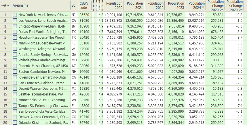 In this Section • Interactive mapping tool .. locate/examine a metro based on address/location. • Interactive Table .. view, rank, compare, each/all metros. • About Metropolitan Areas Mapping Metros -- Examine Metros of Interest .. with drill-down analytics .. using iVDA part of Visual Data Analytics .. more options available using VDAGIS Discovery The start-up view is presented below in an interactive mapping window .. watch video Locate a metro .. see it on a map .. examine its demographics Click a box to view instructions. Find a Metro based on an address/location.. enter an address or location like "San Diego, CA" (no quotes, not case sensitive).. the map view zooms-in to the metro containing the location and shows the metro crosshatched. remove crosshatch with clear button below map window. .. view the demographic profile for this metro displayed in the lower left. .. here you can examine many demographic subject matter items for that metro. .. optionally click on other layers in the Legend Panel. once zoomed in, consider checking on these layers in the legend panel: - "CBSA/MSA 2023 Name" (2023 refers to the CBSA vintage). - "CBSA/MSA 2023" (shows the CBSA with bold brown boundary). .. the address/location is shown by the blue marker .. this is in the metro associated with the address/location used in the searchbar. .. see in the lower left panel the population was 4,875,246 in 2020 and 5,070,110 in 2023 .. for this metro. .. try a different address or location, maybe the ZIP code "85258" or any address/location. .. the view will zoom to that metro. Examine Urban/Rural Patterns.. in the Legend Panel, left of map, click "Urban Layers" ckeckbox on... the map refreshes showing urban areas with a orange/salmon fill pattern; areas not colored are rural. .. click on an urban area in map to view its attributes in lower left panel. .. hide this layer by unchecking the layer checkbox. Examine Patterns of Economic Prosperity by Neighborhood/Census Tract.. in the Legend Panel, left of map, click "Tracts $MHI" ckeckbox on (scroll down in legend panel).click + icon to view legend interval colors/values. .. the map refreshes showing patterns of median household income ($MHI) based on legend intervals shown at left. .. click on a census tract in map to view its attributes in lower left panel. .. hide this layer by unchecking the layer checkbox. Subject Matter Items in metro clipboard, pasted into XLSX. Metro Area Population & Components of Change 2020-2024 interactive table ... goto top Table below contains a row for each 2024 vintage MSA, MetDiv, MISA and component counties. Table initially sorted on CBSA code then Metropolitan Division code then county code. There are 1,844 of total 3,144 counties in the table; only counties in metros are included. Subject matter arrayed across columns show population by year and components of change. Data are based on Census-sourced model-based estimates (released Mar 2025). Click column header to sort; again to sort other direction Click ShowAll button between queries to refresh. Usage notes below table. Mapping, geospatial analysis .. click to start iVDAW .. use interactive map. Interactive Table Usage Notes • Click ShowAll between queries/filters. • Use left-most column to select by state. • Find in Name button; click ShowAll button first .. click Find in Name button to search column 1 for text in edit box. .. text entered in edit box is case sensitive. .. partial names are okay to use. .. click with default value to view all rows with "Harris" (no quotes) Usage note scroll section.
Selected columns buttons
• Pop - click to view population columns. • Rank - click to view ranking columns. • NetChg - click to view net change columns. • Births - click to view births columns. • Deaths - click to view deaths columns. • NatInc - click to view natural increase columns. • IntMig - click to view international migration columns. • DomMig - click to view domestic migration columns. • NetMig - click to view net migration columns. • Population Min & Max> button .. click to show only peer group counties based on values in min and max edit boxes. .. enter the minimum 2021 population in the left edit box. .. enter the maximum 2021 population in the right edit box. • Click ShowAll between queries/filters. Group1 CBSAs 31080 Los Angeles-Orange 40140 Riverside-San Bernardino 41740 San Diego 42200 Santa Barbara 37100 Ventura Group2 CBSAs 32900 Merced 23420 Fresno 25260 Hanford 47300 Visalia 12540 Bakersfield 42020 San Luis Obispo Items in Table
- Areaname
- St - CBSA - MD - StCty - LSAD - BASE2000=4/1/2020 resident total population estimate - POPEST20=7/1/2020 resident total population estimate - POPEST21=7/1/2021 resident total population estimate - POPEST22=7/1/2022 resident total population estimate - POPEST23=7/1/2023 resident total population estimate - POPEST24=7/1/2024 resident total population estimate - CHG2024 - CHG2024p - CHANGE20=CHANGE in period 4/1/2020 to 6/30/2020 - CHANGE21=CHANGE in period 7/1/2020 to 6/30/2021 - CHANGE22=CHANGE in period 7/1/2021 to 6/30/2022 - CHANGE23=CHANGE in period 7/1/2022 to 6/30/2023 - CHANGE24=CHANGE in period 7/1/2023 to 6/30/2024 - BIRTHS20=Births in period 4/1/2020 to 6/30/2020 - BIRTHS21=Births in period 7/1/2020 to 6/30/2021 - BIRTHS22=Births in period 7/1/2021 to 6/30/2022 - BIRTHs23=Births in period 7/1/2022 to 6/30/2023 - BiRTHS24=Births in period 7/1/2023 to 6/30/2024 - DEATHS20=Deaths in period 4/1/2020 to 6/30/2020 - DEATHS21=Deaths in period 7/1/2020 to 6/30/2021 - DEATHS22=Deaths in period 7/1/2021 to 6/30/2022 - DEATHS23=Deaths in period 7/1/2022 to 6/30/2023 - DEATHS24=Deaths in period 7/1/2023 to 6/30/2024 - NATCHG20=Natural Change in period 4/1/2020 to 6/30/2020 - NATCHG21=Natural change in period 7/1/2020 to 6/30/2021 - NATCHG22=Natural change in period 7/1/2021 to 6/30/2022 - NATCHG23=Natural change in period 7/1/2022 to 6/30/2023 - NATCHG24=Natural change in period 7/1/2023 to 6/30/2024 - INTMIG20=Net international migration in period 4/1/2020 to 6/30/2020 - INTMIG21=Net international migration in period 7/1/2020 to 6/30/2021 - INTMIG22=Net international migration in period 7/1/2021 to 6/30/2022 - INTMIG23=Net international migration in period 7/1/2022 to 6/30/2023 - INTMIG24=Net international migration in period 7/1/2023 to 6/30/2024 - DOMMIG20=Net domestic migration in period 4/1/2020 to 6/30/2020 - DOMMIG21=Net domestic migration in period 7/1/2020 to 6/30/2021 - DOMMIG22=Net domestic migration in period 7/1/2021 to 6/30/2022 - DOMMIG23=Net domestic migration in period 7/1/2022 to 6/30/2023 - DOMMIG24=Net domestic migration in period 7/1/2023 to 6/30/2024 - NETMIG20=Net migration in period 4/1/2020 to 6/30/2020 - NETMIG21=Net migration in period 7/1/2020 to 6/30/2021 - NETMIG22=Net migration in period 7/1/2021 to 6/30/2022 - NETMIG23=Net migration in period 7/1/2022 to 6/30/2023 - NETMIG24=Net migration in period 7/1/2023 to 6/30/2024 About Metropolitan Areas ... goto top New Vintage 2023 CBSA/metro delineations are available as of August 2023. See more about the 2023 delineations. Core-Based Statistical Areas (CBSAs) are officially designated by OMB and composed of one or more contiguous counties and must meet a population size criteria of associated Urban Area. CBSAs are classified as the larger Metropolitan Statistical Areas (MSAs) and smaller Micropolitan Statistical Areas (MISAs). Use the interactive table below to view, rank, query 2023 vintage CBSAs by component area. The U.S. Office of Management and Budget (OMB) delineates metropolitan and micropolitan statistical areas according to standards applied to Census Bureau and related data. A metropolitan or micropolitan statistical area has a core area containing a substantial population nucleus, together with adjacent areas having a high degree of economic and social integration with that core. See 2020 Standards for Delineating Core Based Statistical Areas published in the Federal Register. The term "Core-Based Statistical Area" (CBSA) refers collectively to metropolitan and micropolitan statistical areas. Each CBSA must contain at least one urban area of 10,000 or more population. Each metropolitan statistical area (MSA) must have at least one urbanized area of 50,000 or more inhabitants. Each micropolitan statistical area (MISA) must have at least one urban cluster of at least 10,000 but less than 50,000 population. The largest city in each metropolitan or micropolitan statistical area is designated a "principal city." Additional cities qualify if specified requirements are met concerning population size and employment. The title of each metropolitan or micropolitan statistical area consists of the names of up to three of its principal cities and the name of each state into which the metropolitan or micropolitan statistical area extends. Individual CBSAs (MSAs and MISAs) are defined as one or more contiguous counties. Combined Statistical Areas (CSAs) are defined as a set of two or more contiguous CBSAs. County Building Blocks. Current vintage metropolitan and micropolitan statistical area (CBSA) designations are comprised of county building blocks as defined by OMB and updated from time-to-time. Support Using these Resources .. goto top Learn more about accessing and using demographic-economic data and related analytical tools. Join us in the web session. There is no fee for these one-hour Web sessions. Each informal session is focused on a specific topic. The open structure also provides for Q&A and discussion of application issues of interest to participants. ProximityOne User Group Join the ProximityOne User Group to keep up-to-date with new developments relating to metros and component geography decision-making information resources. Receive updates and access to tools and resources available only to members. Use this form to join the User Group. Additional Information ProximityOne develops geodemographic-economic data and analytical tools and helps organizations knit together and use diverse data in a decision-making and analytical framework. We develop custom demographic/economic estimates and projections, develop geographic and geocoded address files, and assist with impact and geospatial analyses. Wide-ranging organizations use our tools (software, data, methodologies) to analyze their own data integrated with other data. Contact us (888-364-7656) with questions about data covered in this section or to discuss custom estimates, projections or analyses for your areas of interest. |
|
|