|
|
|
Mapping New York State Schools
School location information, as conveyed by the latitude-longitude of the school, is essential for analyzing the demographic needs and composition of the area served by the school. School locational data enable viewing geographic information system (GIS) maps of schools in the context of streets, school districts, attendance areas and other earth surface features. Attend Proximity New York School District Demographics & Analysis Workshops and learn how to access and use these data. Use the New York State school point map file on your own computer to analyze schools of interest to you. The map presented below shows all New York state public schools based on 2002-03 data reported to the U.S. National Census for Education Statistics (NCES) by the New York State Education Department. Proximity transformed those data into a "point shapefile" used to prepare the map (click for a larger view). 
The above map includes schools for which the latitude-longitude was provided in the reported data (3,093 schools of a total 4,941 public schools). Mapping software enables a zoom in view. The following example shows Onondaga County area, cities/places (red), and the East Syracuse-Minoa school district. Schools appear as blue icons. 
A further zoom in is shown in the next map. 
A further zoom in is shown in the next map. This map depicts streets with a tabular profile of the street where East Syracuse-Minoa High School is located. 
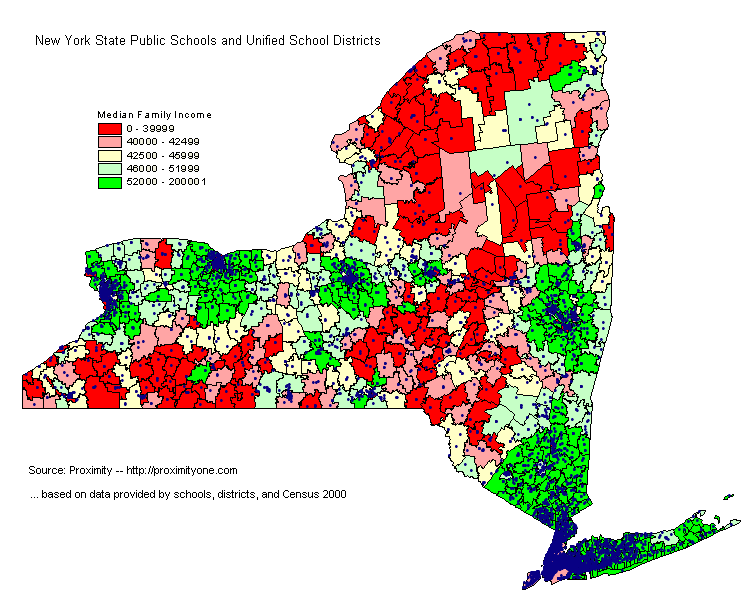 New York Public Schools Now Fully Geocoded
Proximity has geocoded all New York public schools by adding latitude-longitude codes to a database record for each school. The database record includes many attributes about the school. The database is available in the form of a shapefile that may be used with mapping and GIS software to display thematic and locational maps such as the one shown at the right. The geocoded database is only available from Proximity. Contact Proximity for information on content and how to acquire and use these data. 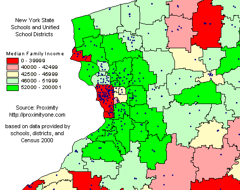 Using mapping software (a no fee version is available), you can zoom in to
regions and areas of interest. The map at the right provides an example of a
zoom-in to western New York state.
Using mapping software (a no fee version is available), you can zoom in to
regions and areas of interest. The map at the right provides an example of a
zoom-in to western New York state.
Click on specific schools and view their attributes. Dispaly a map that highlights all Title I schools (or highlight/size by any other of many school sttributes in the data record). goto top |
|
|