|
|
|
Analysis of School District Demographics by Block Group 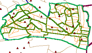 To understand the demographic makeup of a school district requires examining
attributes of smaller area geography comprising the school district.
It is important to understand the school district small area demographics as a basis for planning
and evaluation for not only public education programs, but many other programs and needs
associated with schools and school districts. As an example, see
this section of this document for an analysis of children with disabilities.
To understand the demographic makeup of a school district requires examining
attributes of smaller area geography comprising the school district.
It is important to understand the school district small area demographics as a basis for planning
and evaluation for not only public education programs, but many other programs and needs
associated with schools and school districts. As an example, see
this section of this document for an analysis of children with disabilities.
This web page summarizes characteristics of small area geography within the Alexandria, VA school district. Alexandria is shown in the inset map and is the area designated by the green boundary. School locations (in Alexandria and the broader area) are shown as red icons. The information presented here can be developed for any of the nation's 14,286 public school districts. School District Defined. A school district is an administrative unit, operating with authority and for a geographic area designated by the state department of education, responsible for providing public education for grades within the grade range of K through 12. Unified school districts, as is the case for Alexandria, VA, provide education for all grades. Elementary and secondary school districts, existing in many but not all states, provide education for a specified subset of the K-12 grades. Most school district boundaries do not align with nearby or related city boundaries. The Alexandria City Public Schools school district is geographically coterminous with the City of Alexandria. So, the more simplified process reviewed below would be more complex in many school districts. School Attendance Areas. Most school districts are comprised of many school attendance areas. School attendance areas, or zones, correspond to geographic areas typically established by the school district and relate to boundaries associated with areas served by specific schools. Demographics and School-Related Areas. Most school districts focus attention on students who reside in their jurisdiction and attend their public schools. In most school districts, students are enrolled in private and public schools. As a result, most school districts focus attention only on a part of the population that might attend public school. Administrative demographics tabulated by the schools and school districts normally only relate to students enrolled in those schools, not the total population. For Census 2000, the only source of detailed total population demographics for school districts, the geographic area covered by every public school district corresponds to a unique set of whole census blocks. There are approximately 8.2 million census blocks covered the U.S., wall-to-wall. While the Census Bureau has not tabulated detailed school district demographics, Proximity has developed these data by aggregating Summary File 1 complete count data to school district summaries (see ). This is very useful data as it provides single year of age data for the population by census block (and thus school district) However, the complete count data do not provide the richer demographics provided by the sample based data tabulations released by the Census Bureau in September 2002, in the form of Census 2000 Summary File 3 (SF3). For more information on the scope of data covered by SF3, see http://proximityone.com/cen2000sf3.htm. Tabulations presented below for Alexandria, VA are derived from SF3 and provide a view of the "geographic anatomy of a school district." You can develop similar data for your own areas of interest. A primary limitation of the SF3 data with respect to school district analysis is that the low level geography for which data are tabulated is census block group. Census block groups are clusters of contiguous census blocks. So, the smallest geographic area that can be used as a unit of analysis is the block group. Geographic anatomy of a school district: Census 2000 SF3 data by block group. In the following analysis, demographic data items from SF3 table P36 are used to characterize private and public school enrollment for each block group comprising the school district. Figure 1 shows school enrollment characteristics for Alexandria, VA by census tract and block group. Data shown in the Figure 1 graphic are only for a few of the 99 census block group areas comprising Alexandria. The full set of data is available in a spreadsheet. As shown in the last row of the table in Figure 1, 22.6-percent of those enrolled in PK-12 schools are enrolled in private school. One aspect of the power of this spreadsheet is that it shows the number and percent of public versus private enrollment with a fine geographic granularity. Figure 1. School enrollment characteristics for Alexandria, VA by census tract and block group 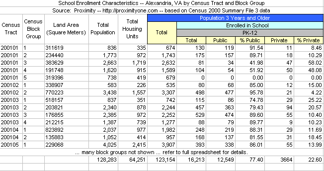
But looking at the spreadsheet alone does not tell where these block groups are located in a way that is meaningful to most readers. Likely no reader would know where block group 2 of census tract 200102 (sometimes written 2001.02) is located. A map is needed to show these locations, such as shown in Figure 2. In this map, the census tracts are shown with red boundaries. The 6-digit census tract codes are provided in the census tract area. Each census tract is further subdivided by block group. The single digit block group code (must be associated with tract code) is provided in each block group area. Figure 2. Map of Alexandria, VA by Census 2000 census tract and block group 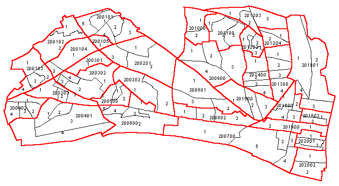
Is that it? What about other demographics?. The data presented above are the "tip of the iceberg." A next question might be ... what is the enrollment by public/private school by grade? These data are also included in table P36 and by gender. A sample of these data for one block group is provided in the following table. The complete set of data are available in this spreadsheet. P36. School Enrollment by Level of School by Type of School/Grade for Population 3 Years and Over Universe: Population 3 years and over Total Enrolled in nursery school, preschool: Public school Private school Enrolled in kindergarten: Public school Private school Enrolled in grade 1 to grade 4: Public school Private school Enrolled in grade 5 to grade 8: Public school Private school Enrolled in grade 9 to grade 12: Public school Private school Enrolled in college, undergraduate years: Public school Private school Enrolled in graduate or professional school: Public school Private school Not enrolled in school More demographic data. There are hundreds of relevant tables, corresponding to other demographic attributes of these same block groups that are available. A sample of the broader data are shown in this Alexandria, VA 1990-2000 demographic trend profile (Excel spreadsheet). Most of the Census 2000 items shown in this profile are available at the block group geographic level. Youth with Disabilities. From the spreadsheet referenced above, it is found that there are 1,405 persons ages 5-to-20 years (of total 16,234 persons this age group) who have a disability. How are these people distributed across the school district? How can plans be made to support their special needs? One source of information is to create a map of the school district by block group. Such a map appears in Figure 3. This is one example of what other types of related analyses can be performed with this scope of demographic data. See the reference section for more information on the concept of disability as used here. Figure 3. Persons 5-to-20 years of age with a disability: Alexandria, VA by block group 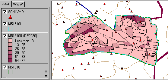
More about geography. There are several supplemental sources of maps that can be useful in the foregoing analyses.
Start Software. After expanding the above referenced zip and install files, start the ArcExplorer software. Open the project file named c:\alex\alex1. Do not re-save this project file with the same name or you might lose important reference information used in this tutorial. It is suggested that that you save any changes to a new project file named c:\alex\alex2.aep. The initial display screen should appear as shown in Figure 4. Figure 4. Initial Map View 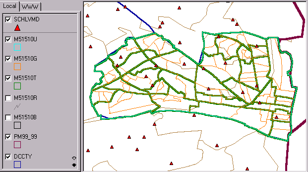
Attributes of Individual Schools The schlvmd.shp shapefile contains data are for the 2000-2001 school year and have been developed from data tabulated by the respective school districts. There are 1,985 schools in this file, covering all public schools in Virginia, Maryland, and D.C. Schools in Alexandria, VA are listed in Figure 5. A few of the attributes associated with each school are shown in this spreadsheet screenshot. Figure 5. Schools in Alexandria, VA 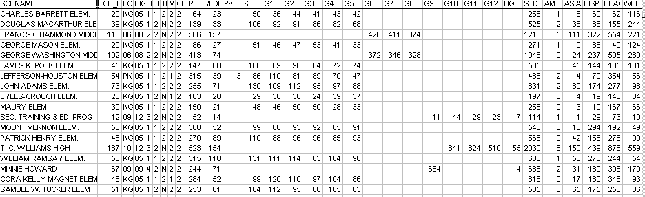
Using the map project resources, a few attributes of T.C. Williams High School are shown in Figure 6. Figure 6. Query to T.C. Williams High School 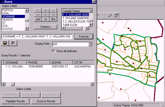
More detailed attributes of the same school are shown in Figure 7. This profile shows enrollment by grade, number of students free and reduced lunch, number of students reduced lunch, total students, teacher full time equivalence, among other fields. Any school in VA, MD, or DC may be similarly analyzed. Figure 7. Using Identify Tool to Profile T.C. Williams High School 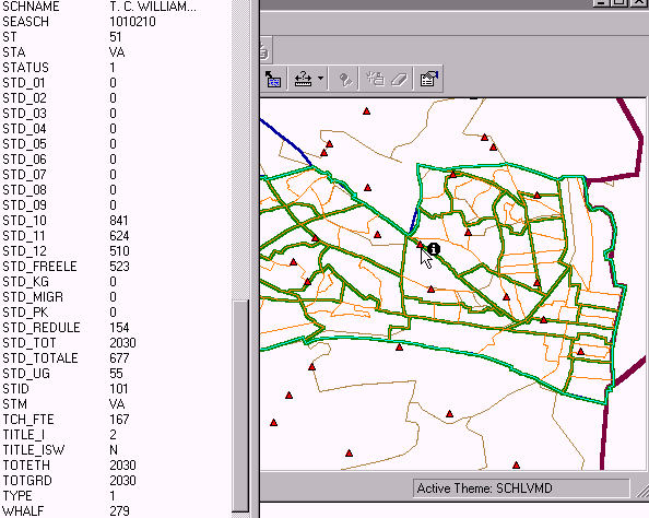
Thematic Maps of Census Blocks The focus of this document is placed on block group level geography since that is the lowest level Census 2000 tabulation geography for which "richer demographics" are available. Many applications can benefit from use of census block level geography even though the scope of subject matter available is greatly reduced. In the case of Alexandria, VA, there are 1,023 census blocks compared to 99 block groups. Figure 8 shows a thematic map that depicts the Asian population by census block for Alexandria, VA. Technically, this data corresponds to the population that responded as being of only one race and Asian on the Census 2000 questionnaire. The legend to the left of the map shows the size of the Asian population by census block in Alexandria. Viewing the map, it is evident that there is one census block included in the "top interval" having more than 410 persons that are Asian and of one race and where this census block is located. Figure 8. Asian Population by Census Block 
You can examine these data on your own computer using the map project resources described above. The alex1.aep project includes the Alexandria by census block shapefile that is loaded with more than 100 demographic attributes for each block. The subject matter items are listed at http://proximityone.com/dp2000et.htm. goto top Reference Notes Disability status. This document provides data on the population 5-to-20 years of age who have a disability. More precisely, the data are for the noninstitutionalized civilian population in this age range who have a disability. The interval 5-to-20 years is used because of the way the data are collected and tabulated from Census 2000. People 5 years old and over are considered to have a disability if they have one or more of the following: (a) blindness, deafness, or a severe vision or hearing impairment; (b) a substantial limitation in the ability to perform basic physical activities, such as walking, climbing stairs, reaching, lifting, or carrying; (c) difficulty learning, remembering, or concentrating; or (d) difficulty dressing, bathing, or getting around inside the home. In addition to the above criteria, people 16 years old and over are considered to have a disability if they have difficulty going outside the home alone to shop or visit a doctor's office, and people 16-64 years old are considered to have a disability if they have difficulty working at a job or business. goto top |
|
|