|
|
|
Urban/Rural Geodemographics and Census 2000 Many of us desire to analyze geographic areas in terms of their urban or rural character -- for many reasons. While there are varying definitions for urban and rural, perhaps the Census Bureau definitions and related data are most widely used. On May 1, 2002, the Census Bureau released new data for each of the Nation's 466 urbanized areas (UAs) and 3,172 urban clusters (UCs) based on Census 2000. The number of areas compares to 405 urbanized areas for the 1990 Census. The concept of urban clusters is new for Census 2000. For more information, see the Census 2000 Data Access and Use website. This section provides an example of using the latest Census 2000 data and urbanized area delineations for the Lawrence, Kansas metropolitan area. Based on Census 2000, the city of Lawrence, KS had a population of 80,098 as of April 1, 2000. The Census 2000 population of the Lawrence, KS urbanized area is 79,647. An immediate question is how and where do these numbers differ. The easiest way to answer that question is with a map. How can you develop maps like these for your areas of interest? See a summary of the process used to develop these maps at the end of this section. Map 1. Lawrence, KS Urbanized Area (yellow highlight) In the following map, Census 2000 census blocks comprising the Census 2000 Lawrence, KS urbanized area are shown in yellow. The 1990 Census Lawrence, KS urbanized area boundary is shown in blue. Other census blocks in Douglas County (containing Lawrence) are shown as a thematic map depicting total population defined by the color-coded intervals at the left of the map. 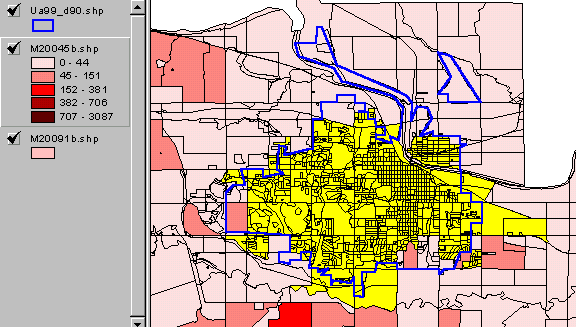
Map 2. Lawrence, KS Urbanized Area compared to Incorporated City Boundary The following map is simialr to Map 1 with the addition of the City of Lawrence incorporated boundary shon in green. Some parts of the city extend outside of the UA while other areas within the city are not within the UA. 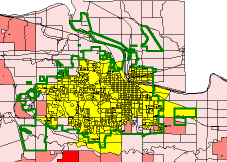
Map 3. Lawrence, KS Area Population by Census Block The following map is similar to Map 2 with the UA highlight removed. This map reveals the population size by census blocks for the entire area. The Lawrence city corporate boundary is shown in green. 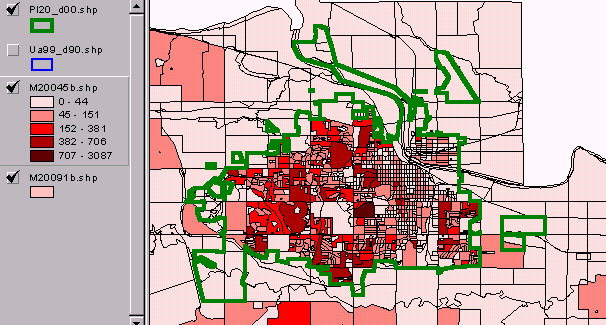
Assigning Urban Area Codes to census blocks. Consider the application where you have a county by census block shapefile(s) and want to be able to depict the Urban Area Code (UAC) in which each census block is located in a map display. One way to achieve this objective is to add the UAC to the county by census block shapefile dbase file. Then, a query can be performed to identify those census blocks which are in a particular UAC. Though there are many ways to develop such a file, here is one method. The UAC and geocode hierarchy to get to the block level are contained in the composite of Census 2000 UA TIGER/Line files 1, A, and I. The appropriate TIGER/Line files can be downloaded from the Census server and processed with the Proximity TGR2DBF software creating a dbase structured version for these three TLFs. Next use TGR2DBF to create a census block-to-UA/UC code equivalency file (BLKUA.DBF). Next acquire the county by census block shapefile(s) from the Proximity map files website. Use the Proximity Cen2Shp software to merge the UA/UC code from the BLKUA.DBF into the county by block shapefile dbf. The augmented shapefile is now ready to support a display (or data link) of census blocks by user selected UA/UC. If the objective is to obtain a UA boundary file, the county by census block shapefile could be "dissolved" on the UA code to create the UA boundary. goto top |
|