|
|
Module 1 Module 2 Module 3 Module 4 |
Welcome to the GIS & GeoDemographics WebCourse ... 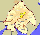 Participate in this Webcourse at your own pace to learn how to use mapping and Geographic
Information System (GIS) software with geodemographic data.
Participate in this Webcourse at your own pace to learn how to use mapping and Geographic
Information System (GIS) software with geodemographic data.
Click on the graphic at the right to view a geodemographic analytical project focused on the Philadelphia-Camden-Vineland, PA-NJ-DE-MD CSA. See examples of maps, data, and analyses that you will be able to develop and use for your areas of interest after completing the WebCourse. Course Objectives • Learn about mapping components and concepts for geodemographic analysis. • Understand what demographic data resources are available. • Understand how to access available demographic data resources. • Be able to draw thematic and orienteering maps using geodemographic data. • Be able to use an array of GIS tools in geodemographic analysis. Course Modules
Resources Used in the Workshop All software and data required for the workshop are included. These resources are yours to keep and use permanently. -- CommunityViewer GIS -- TLFGeocoder -- Demographic Trends Database Participation Visitors to the WebCourse may view the course modules listed above. Access to more detailed course module information requires registration. General information about this course and registration is available at http://proximityone.com/vc2.htm. |
|
|