|
|
|
ProximityOne - Integrated Software Suite for Decision Making
The ProximityOne software suite overcomes the limitations of traditional hierarchical, function-oriented, and fixed-purpose structures characteristic of many data processing and decision support resources. For example, geographic information systems have "grown up" to now operate in a separate, non-integratable, structure. ProximityOne and Census 2000 Data Access and Use The present ProximityOne generation is substantially geared to processing Census 2000 geographic and demographic data and enabling users to integrate these data with non-Census data for analysis. However, non-Census 2000 data integration operations are also supported. The graphical overview presented below visually summarizes how ProximityOne suite components relate to each other, data, and decisionmaking information development. Information about components is summarized below the graphic. Click on ProximityOne components for more detailed information. 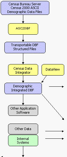
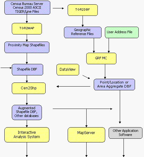
ProximityOne Integrated Suite. The ProximityOne Integrated Suite is the collective set of ProximityOne suite components organized to meet your needs. Your personal integrated suite is the composite set of standalone, web-enabled, and/or or local network component based software, data, models, and linkage. Mix and match these elements to meet you needs. Add or remove components as your requirements change over time. Open architecture. ProximityOne components are developed in an open, component-oriented, architecture enables you to leverage other resources - data, software, models, interfaces, and more. For any organization. The architecture of ProximityOne enables it to adjust to the size and operational requirements of any organization. The modular structure of the ProximityOne components enable you to choose those parts required for your applications. ProximityOne Suite Components (standard suite components) ASC2DBF -- converts ASCII data [free Census web server download] to database structure for use with other Proximity Census 2000 software and other standard dBASE file processing software. Census Data Integrator -- data mining software enabling the user to selectively extract specific subject matter for specific geographic areas. Cen2Shp -- automatically interfaces (creates and integrates) demographic data from ASC2DBF generated database files into ArcView shape dbf files -- based on downloadable map shapefiles from Proximity web server. Cen2Shp merges data from any set of dbase files. Independent of Census data, merge data from one dbase file with another dbase file, based on a flexibly defined user key, and create a new merged dbase file. Or, add attributes from a database where you have stored data for street segments to the streets shapefile dbase file. DataView -- generalized database file viewer and processing utility designed for use with any standard/generic dBASE files. Interactive Analysis System -- used with Proximity databases to generate tabular reports and comparative analysis profiles; perform queries; perform generalized Excel file read and write operations; and perform generalized dBASE file read, write and process operations. ProximityOne Suite Components (extended suite components -- add-on to standard suite) TGR2GRF -- converts TIGER/Line files to to dbase structured geographic reference files enabling address-matching, geocoding and related cartographic applications. GRF MC - address-matching and geocoding software assigning latitude-longitude coordinates to user supplied address data, assigns geocodes for matching with other data, and aggregates address data to geographic areas. Licensing. Prices are for single user (one CPU) licenses. Inquire for site license prices. |
|